


NEWS
NEW MTB SIGNAGE
You may have noticed some changes while riding the trails: all our mtb trail name signs have been replaced, and new maps have been installed.
![]()
Mont Rigaud is now aligned with the new signage standards from Vélo Québec, including clear, standardized pictograms to help you navigate confidently and ride safely.
We want to remind everyone of the importance of staying in control, knowing your limits, and checking the classification, type, and difficulty level of a trail before riding it. The Vélo Québec Mountain Biking Code of Conduct is posted at the ticket counter. We invite all riders to review it before hitting the trails.
Here's how to read the new pictograms you'll see on the mountain:
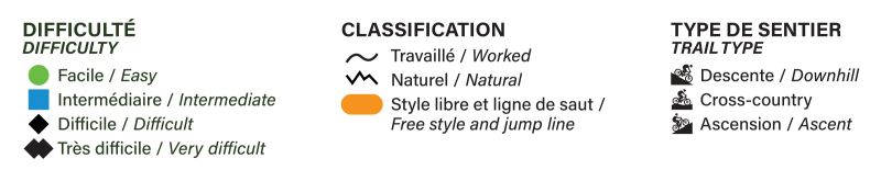
DIFFICULTY LEVEL
The first pictogram (shape and colour) indicates the difficulty level of the trail.
- GREEN CIRCLE: easy trail, for beginner riders with basic technical skills
- BLUE SQUARE: intermediate trail, for riders with fundamental technical skills
- BLACK DIAMOND: difficult trail, for riders with advanced technical skills
- DOUBLE BLACK DIAMOND: very difficult trail, for riders with advanced skills and comfort with risk
CLASSIFICATION
The classification is shown by a line within the difficulty pictogram or by a yellow pill around it.
- WORKED: wavy line — flowy trail with natural or built features
- NATURAL: broken line — uneven trail with rocks, roots, and natural obstacles
- FREE STYLE / JUMP LINE: yellow dot — trails with built features optimized for jumps
TRAIL NAME
The trail number and name are displayed to the right of the difficulty and classification pictogram.
TRAIL TYPE
A second pictogram, to the right of the trail name, shows the trail type.
- DOWNHILL: descending trail with negative elevation
- CROSS-COUNTRY: mostly flat trail with small climbs and descents
- ASCENT: climbing trail, usually leading to the start of other trails at the summit
This update reflects our commitment to offering a trail network that's safer, more inclusive, and easier to navigate — whether you're a beginner or an expert rider.
Good news: our trail map is now available on ONDAGO, a Quebec-based app! Download the map for real-time GPS guidance — even without a network — and explore our trails with confidence.
A big thank-you to our amazing community for your feedback and passion for mountain biking.
We wish you a fantastic season!